

Laser Systems for Object Detection and Three-Dimensional Mapping
Technology Platform, January 19. 2026
AI GENERATED
Yehoshua Kalisky, Anna Sokolenko, and Iky Hazan
The laser is an auxiliary tool on the modern battlefield, used either as a weapon—such as a high-power laser—or as a supporting means, such as a target designator or range finder. One of the most prominent uses of lasers is as a type of sensor, or a kind of sensitive radar, for detecting stationary or moving objects and for highly accurate area mapping, in a system known as LiDAR (Light Detection and Ranging).
The purpose of this article is to highlight the application of laser-based systems for object detection and precise terrain mapping, focusing on the inherent advantages of laser-based LiDAR systems compared with conventional radar systems. This topic, which is currently at the forefront of technological development, is of great importance to the State of Israel, both in various civilian aspects and in military–security aspects, as detailed below. For this reason, we believe that Israel should initiate independent research and development and encourage domestic industries and academic institutions engaged in research and development related to LiDAR systems to undertake joint efforts to develop such systems for a wide range of applications, in cooperation with reliable local and foreign partners. Since LiDAR components are vulnerable to disruption or cyberattacks, with the potential to damage critical infrastructure such as industrial and defense facilities, effective protective measures for these systems must also be developed.
Technological Background
LiDAR, like RADAR, is a system based on the transmission of electromagnetic (EM) waves and the reception of their reflections from objects in space. The difference between these systems lies in the type of transmitter and the nature of the transmitted wave, as summarized in Table 1.
Table 1.
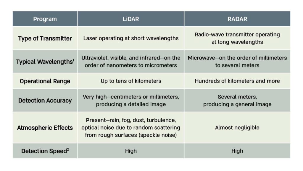
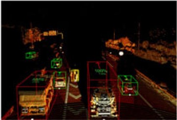
Figure 1. The Difference Between a RADAR Image (Right) and a LiDAR Image (Left)
Figure 3. An Electromagnetic Bomb Based on High-Power Microwaves

The operating principle of LiDAR-based terrain mapping relies on scanning a given area using a laser or another coherent electromagnetic source and measuring the time required for a laser pulse to reach a specific target and return to the transmitter. This time is known as the Time of Flight. Knowing two critical parameters—the measured time and the constant speed of light—allows for the calculation of the distance from the transmitter to a specific point. Computer processing of the reflected beam enables the extraction of characteristic parameters such as amplitude and phase, yielding a three-dimensional image of the scanned area. This process is typically carried out using lasers operating at megahertz frequencies (millions of pulses per second), enabling the generation of a three-dimensional image of a large area in the form of a point cloud. Signal detection is usually performed using active imaging, meaning that the detector is activated only after a predefined time window to collect relevant information returned from the target while rejecting randomly scattered signals or optical noise.
Due to the short wavelengths of LiDAR systems compared with the long wavelengths of radar systems, LiDAR offers several advantages beyond improved resolution:
- Simple, compact, and modular system architecture;
- Relatively simple maintenance;
- Low cost due to the use of standard components from the optics, photonics, and telecommunications industries;
- Higher reflectivity from the target, since reflectivity increases as wavelength decreases;
- Very high distance-measurement accuracy and resolving power, enabling precise real-time 3D terrain imaging;
- Better beam focusing on the target than radar systems, due to lower beam divergence at shorter wavelengths;
- Detectors in short-wavelength ranges are efficient, sensitive, inexpensive, and widely available.
Structure of a LiDAR System
A three-dimensional LiDAR mapping system consists of the following components:
- A laser system operating in continuous or pulsed mode, with high coherence, depending on civilian applications or military operational requirements;
- Power supply systems for the laser, detectors, computing units, and data-processing systems;
- An opto-mechanical system (based on moving mechanical components) or electronic switching for steering the laser beam, enabling spatial scanning of the target and maintaining spatial stability using GPS or other global navigation systems, as well as efficient collection of reflected light;
- A reflected-signal detection system: either an active system in which the detector collects signals within predefined time windows or a passive system in which detection is continuous;
- A computerized system for data processing, background-noise filtering, and terrain-image generation based on the collected signals—3D point cloud representation;
- A control, monitoring, and synchronization system for the various LiDAR components;
- A processed-data display system and user interface.
Figure 2. Schematic Illustration of a Basic LiDAR System
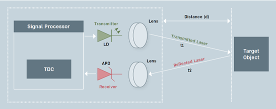
Legend
- LD denotes the laser transmitter
• APD—a detector for the returned radiation
• TDC and the signal processor are the digital processing units for the laser signals transmitted toward the target (transmitted) and the signals reflected from it (reflected)
LiDAR Detection Methods
The following main detection methods are used:
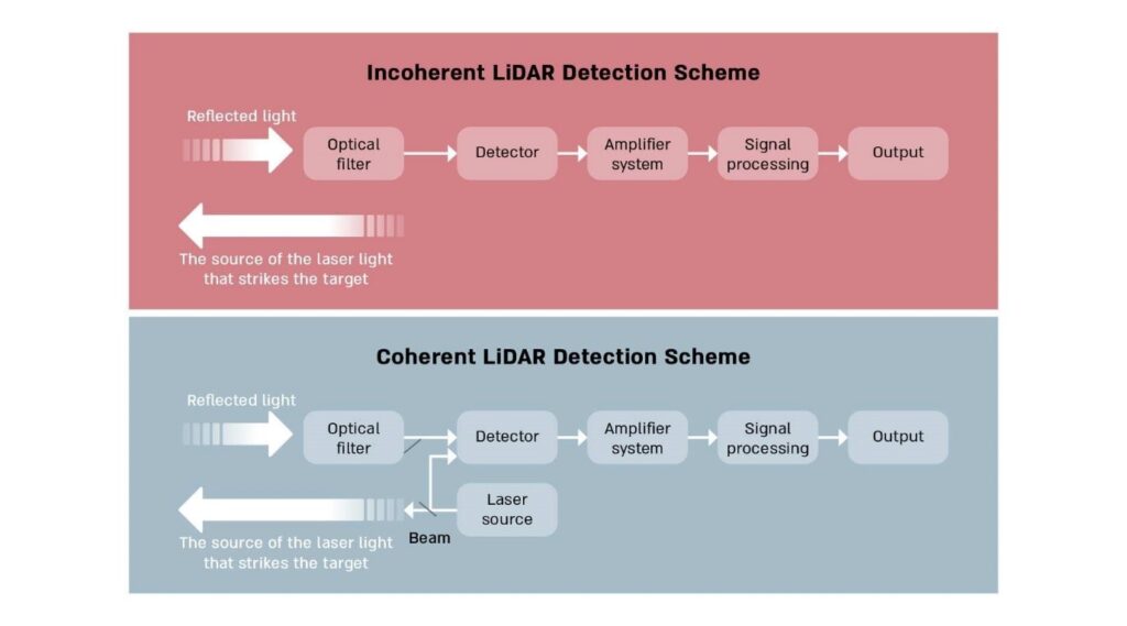
Incoherent method—The light reflected from the target is collected directly by the detector for decoding and mapping. This is a relatively simple method with potential for errors due to the detection of scattered light from the target at many different angles relative to the laser beam incident on the target (diffuse reflection). This may result in a distorted and blurred surface image or target image (see Figure 3).
Coherent method—The light reflected from the target, together with a portion of the laser light (a reference beam) originally transmitted toward the target, is collected by a detector or an array of detectors in order to compare the properties of the light before it strikes the target with its properties after reflection. This comparison yields a more accurate surface image (see Figure 3).
Figure 3.
Quantum LiDAR Detection
Quantum LiDAR systems are based on measurements that illuminate the target using photons—the fundamental particles of light—exploiting their unique quantum properties. This approach, known as quantum illumination, applies quantum phenomena such as entanglement and squeezed states to enhance sensitivity and measurement accuracy. Compared with classical radar systems, quantum LiDAR offers improved detection of small objects and more accurate estimation of distances and dimensions.
Modern LiDAR systems integrate compact, advanced lasers across multiple wavelengths with high-speed solid-state scanning and detection systems, reducing size and power consumption while improving overall efficiency. An additional innovation is 4D imaging, which adds the height dimension to spatial and velocity dimensions, providing highly accurate, real-time terrain and environmental images, while enabling high-resolution object identification through the application, processing, and presentation of data in Point Cloud.
Detection via Entanglement
Detection using quantum LiDAR is a significant enhancement of the coherent method through the application of the principle of entanglement to quantum particles such as the fundamental particles that make up light and electromagnetic radiation—namely, photons. An entangled state between quantum particles is a special condition in which two or more quantum particles share common properties, such that measuring one of these properties instantaneously affects the other particle, regardless of the distance between them. It is important to emphasize that this influence is instantaneous even if the two particles are separated by an infinite distance. In principle, it is possible—using various complex physical methods—to generate pairs of entangled photons that are transmitted simultaneously toward the target and toward the detector; any change in the reflected wave is also manifested in the reference wave, thereby producing an amplified signal.
Detection via Quantum Interference (Correlation or Quantum Interferometry)
In this method, a highly coherent laser beam is used to measure time differences (that is, phase differences of the electromagnetic waves) between laser beams reflected from the target. These time differences are translated into distance differences, which typically yield an accurate image of the examined target. This method has a fundamental drawback arising from the influence of atmospheric factors—such as temperature gradients and attenuation of beam intensity—on the desired measurement results.
Detection via Squeezed States
This method is an enhancement of detection via quantum interference. This technology—without delving into physical details—exploits the fact that it is possible to reduce the background noise of a specific measurable quantity characterizing quantum particles, including light particles (photons), and thereby increase by an order of magnitude the measurement sensitivity of that quantity, even when the reflected signal is extremely weak. These special states are known as squeezed states. For example, distance or elevation dimensions can be derived—and even amplified—with accuracy on the order of a few centimeters, based on measurements of extremely small time differences between the incident beam and the reflected beam resulting from variations in the examined surface (in professional terminology: measurement of the phase of the electromagnetic wave). In this way, a surface image with very high precision can be obtained.
In general, it is important to note that current LiDAR systems integrate innovative, compact laser systems operating across a range of wavelengths with high-speed scanning and detection systems based on solid-state devices. This integration reduces system size and power consumption while increasing overall system efficiency.
Applications of LiDAR Systems
Beyond three-dimensional mapping capabilities and the acquisition of precise topographic information, which are discussed in this article, it is important to note that LiDAR systems have applications across many additional fields:
Civilian Applications
- Autonomous vehicle industry: The system enables real-time object detection and safe navigation in dynamic driving environments.
• Integration of LiDAR systems into various transportation platforms: The technology is incorporated into drones, trains, and airport transportation systems to support object detection and safer navigation through three-dimensional vision.
• Infrastructure monitoring: The system is used to supervise and assess the condition of pipelines, power lines, and railway networks, enabling early detection of structural weaknesses and environmental hazards.
• Integration of LiDAR in the robotics industry: Applied across various industries, including the automotive sector, complex navigation, semiconductor manufacturing, and the production of advanced electro-optical components.
• Agricultural applications: Analysis of land suitable for agriculture; crop management through monitoring crop quality or potential damage to agricultural produce over large areas.
Urban planning: City planners integrate the system with artificial intelligence capabilities to generate three-dimensional models in order to build “safe cities.” These enable real-time monitoring of accidents and security threats in a rapid and efficient manner and assist in traffic management. The system also helps optimize municipal services, such as waste management and energy distribution, as well as the monitoring and allocation of resources for relevant infrastructure.
Military and Security Applications
- Battlefield mapping: The system enables precise analysis and real-time three-dimensional mapping of terrain, including in urban environments.
• Enemy detection: The system assists in accurately locating enemy positions and infrastructure.
• Autonomous ground vehicles or aircraft, robotics, and navigation: The system provides detailed information about the spatial environment, obstacle detection, identification of drones or UAVs, and improves mobility and navigation capabilities even in complex and hostile environments.
• Underwater mine detection: The system measures the depth at which mines are located.
•Real-time battle damage assessment (BDA)
• Detection of hazardous chemicals (chemical warfare): Using LiDAR devices, it is possible to detect the presence of various gases and identify their type and concentration, including toxic gases used in chemical warfare. The device emits laser beams at wavelengths corresponding to the absorption lines of the substance and measures the amount of absorbed light; from this data, information about the examined substance and its concentration can be derived.
• Support for laser weapons: A LiDAR system predicts the performance of laser weapon systems by analyzing atmospheric processes and environmental conditions and can also identify missile flight trajectories.
• Defense and remote protection: Various electronic and electro-optical systems enable detection of attacks on critical infrastructure or cross-border attacks, identification of security breaches or defensive lines, thereby allowing optimization of defensive measures.
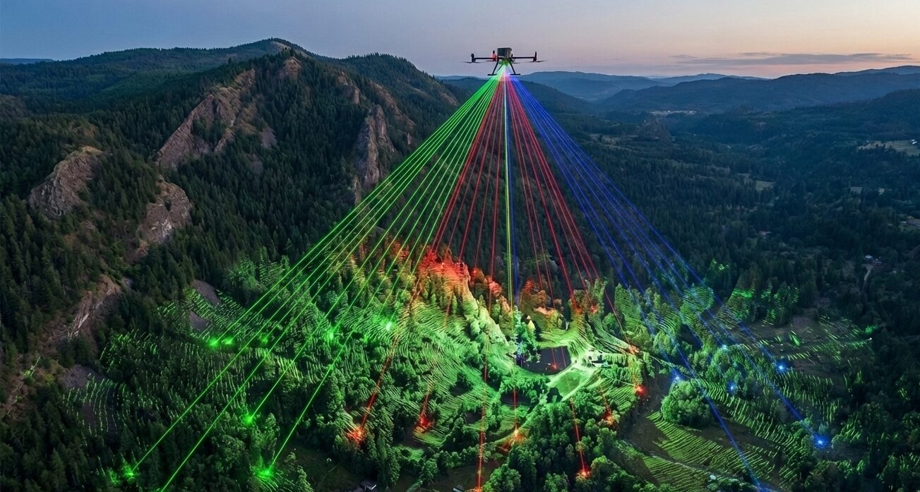
• High-altitude surveillance and reconnaissance capabilities: Systems such as DARPA’s HALOE map large areas and enable advanced data collection from altitudes exceeding 30 kilometers above the surface. Figure 6 presents a schematic demonstration of large-area three-dimensional mapping using a LiDAR system mounted on a drone.
Figure 4 Schematic Illustration of Large-Area Three-Dimensional Lidar Mapping From an Aerial Platform
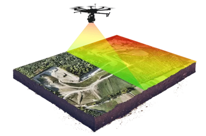
Note. Taken from LiDAR Technology Explained
Leading Companies in the LiDAR Field
The activities of leading companies in the LiDAR field are derived from applications in both civilian and military–security domains, as described above. In several companies, civilian and military–security applications are integrated. The following is a focused review of a limited number of major companies leading the field in the United States, China, Russia, and Germany.
Velodyne LiDAR: One of the primary and veteran companies in the United States in the field of laser-based distance-measurement applications. In 2016, the company became a developer of LiDAR systems for autonomous vehicles, aviation, mapping, robotics, and the creation of digital infrastructure as part of smart-city systems.
Ouster. The company specializes in the production of sensors for LiDAR systems, particularly solutions for industrial environments. In 2023, it merged with Velodyne LiDAR.
It should be noted that Velodyne LiDAR and Ouster also develop military applications. The companies supply LiDAR sensors for the detection and tracking of targets or military movements, battlefield mapping, robotics, and navigation systems for unmanned aerial vehicles and unmanned reconnaissance vehicles. Jointly, they develop advanced sensors with high durability that meet military standards.
Aeva Technologies, Inc. Founded in 2016, the company specializes in the development of LiDAR technologies based on system miniaturization and laser-beam encoding using frequency modulation to enhance detection sensitivity. It also develops related systems such as sensors and dedicated software for autonomous vehicles, industrial automation systems, and autonomous laboratory testing systems used in industry (metrology).
Hesai Technology and RoboSense. Competing Chinese companies with similar products, founded in 2014. Their areas of specialization include the development of LiDAR systems and sensors for autonomous vehicles, robotics, and industrial systems. With regard to Hesai Technology, suspicions have been raised concerning developments with a military orientation.
China South Industries Group Corporation. The Chinese conglomerate developed a four-legged robotic platform resembling a wolf, which uses LiDAR sensors to scan its environment. These robotic “wolves,” intended to support Chinese military forces on the battlefield, are capable of operating in difficult terrain, carrying weapons, firing accurately, and functioning as a coordinated pack.
AGM Systems. A Russian company that declares it operates UAVs and drones equipped with LiDAR sensors for three-dimensional mapping across a range of civilian applications, including infrastructure, land surveying, forestry, and mining. The company is active in the Russian war effort in Ukraine, apparently for battlefield mapping using UAVs, and has therefore been sanctioned by the US Department of the Treasury.
Blickfeld GmbH. A German company founded in 2017. Its activities focus on the development of hardware and software components for LiDAR systems in the fields of smart transportation, autonomous vehicles, and industrial automation.
Figure 5. An Example of Spatial Scanning Performed in an Autonomous Vehicle by a LiDAR System Manufactured by Velodyne LiDAR
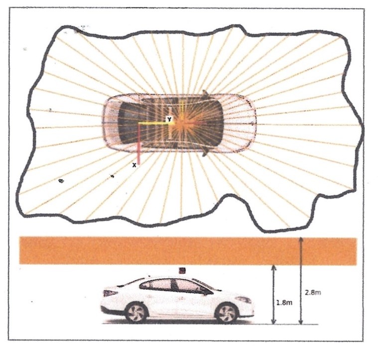
Note. Taken from S. Nobili, S. Dominguez, G. Garcia, and M. Philippe, “16 channels Velodyne versus planar LiDARs based perception system for Large Scale 2D-SLAM,”
Future Developments
In the coming years, improvements in LiDAR technologies are expected in the following areas, as summarized in the Table 2.
Table 2.
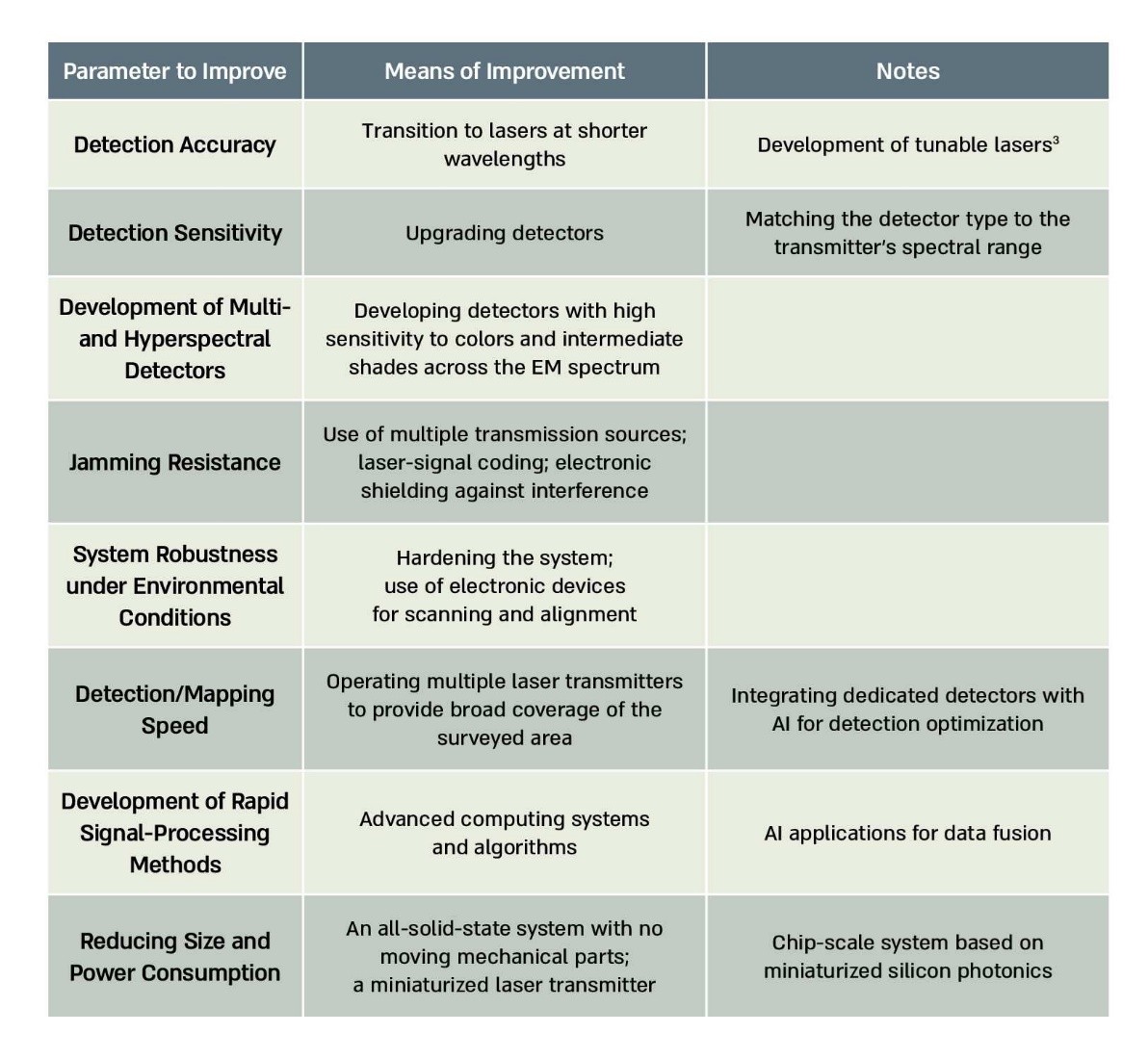
In summary, it is possible to significantly improve detection accuracy, sensitivity, robustness under harsh environmental conditions, and the ability to identify threats at high speed. The integration of artificial intelligence (AI) into LiDAR systems will enable more sophisticated real-time analysis of terrain and spatial data.
Implications for the State of Israel
The State of Israel possesses extensive technological infrastructure, including skilled human capital and research institutes, enabling the development and production of advanced LiDAR systems. This infrastructure allows Israel to lead a focused effort to develop such systems for a wide range of applications, both civilian and military–security. These include the development of imaging systems for the future battlefield with higher resolution and discrimination capabilities compared to conventional radar, as well as additional security applications as detailed above.
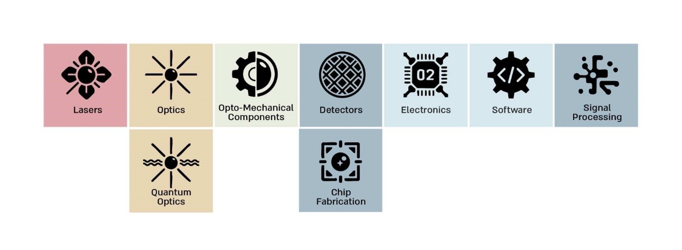
The relevant fields that constitute the foundational building blocks of LiDAR systems include, inter alia: optics, lasers, opto-mechanics, detectors, chip design and manufacturing, quantum optics, software development and cyber warfare, electronics, and signal processing (see Figure 6).
Figure 6. Foundational Building Blocks of LiDAR Systems
For example, Innoviz, a leading Israeli company in its field, develops traffic management systems; an illustration of its activity is shown in Figure 9.
Figure 7. Traffic Management Systems
From this capability derives the potential to develop highly miniaturized, high-precision LiDAR systems for additional applications and across diverse platforms. Israel’s proven technological capabilities also enable cooperation with parallel and leading industries in Europe and the United States while leveraging Israel’s relative advantages in the areas reviewed above. However, it is important to note that any cooperative development of LiDAR systems entails significant risks, and the preferred approach is independent development without reliance on foreign actors, for the following reasons:
Local Development of Effective Defensive Measures for These Systems—What Are the Risks?
LiDAR-based control and mapping systems, in both civilian and military–security contexts, typically consist of hardware and software components such as:
- Data transmission and reception means.
• Dedicated software for control and data processing.
• Data storage in cloud-based systems or local storage media.
• Communication—usually wireless—between networks of multiple LiDAR systems.
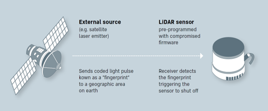
These components are vulnerable to disruption and cyberattacks through the transmission of false optical signals or high-power electrical pulses, interference with operating software and data-processing systems, as well as leakage of critical data to hostile actors. Damage to or disruption of any of these components may cause harm to essential municipal services, infrastructure, transportation, industrial and automation facilities, and result in significant security damage. A schematic illustration of a potential attack scenario—via the transmission of a false optical signal from space to a LiDAR detector system—is shown in Figure 10.
Figure 8. Potential Attack Scenario
Preventing the implantation of chips and data-transmission software: Local and as-independent-as-possible development is required to prevent the implantation of miniature chips or malicious software that cannot be detected and whose purpose is to image critical sites and transmit data from the databases collected by LiDAR systems.
Control over the supply chain of critical components: To avoid shortages of critical components for LiDAR systems, the government must ensure a reliable supply chain, preventing shortages of essential inputs for these systems, such as rare minerals, rare earth elements or ores.
In conclusion, Israel should initiate independent development and encourage domestic industries and academic institutions engaged in research and development of LiDAR systems to cooperate on this issue—across both civilian and military–security dimensions—with local actors and reliable foreign partners. This should be achieved through the promotion of partnerships and generous government support in order to provide optimal protection for Israeli-made (“blue-and-white”) LiDAR systems.